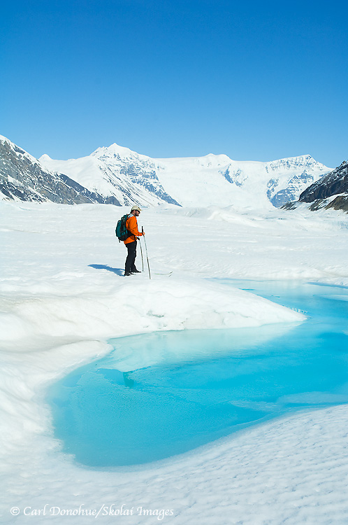
Backcountry skiing, exploring the Root Glacier, with Stairway Icefall in the background. Springtime brings melt, opening a small pool of water on the glacier’s surface. Cross country skiing, Wrangell-St. Elias National Park and Preserve, Alaska. Please click on the image above to view a larger version of this photo.
Hey Folks,
I think art involves exploration, the process of stepping into the unknown, and taking a journey of sorts. In this way, I think we might relate the idea of art to the idea of “icon photography” discussed earlier. Seeking out the new is a vital fragment of making art, in my opinion.
At some point, we delineate art from craft. Art, to me, involves a greater element of the unknown, while craft is more a process of refinement and control. One hones one’s craft, but I don’t think that’s necessarily the case with art. Art might simply involve turning a new direction with each step (though maybe it doesn’t have to do so). We don’t have to refine anything.
On a trek through the mountains, I enjoy the exploration, the wander itself. Though I guide hikes in places I’m obviously familiar with, I make an effort to reserve at least a trip or 2 each season as an exploratory hike. This summer, for example, we’re heading out on a Arrigetch Peaks backpacking trip in Gates of the Arctic National Park. A park I’ve visited once, my very first remote hike in Alaska (wow, what a great memory that is). Venturing into the unknown is an artful process; a game of chance. I don’t know what we’ll find on the trip, and that itself is motivation for the undertaking; to simply experience that gift of the hidden.
Jazz musicians understand this, every time they step to the mic to improvise a solo they do exactly this. That’s the beauty of jazz. That’s also the beauty of art. The other is artifact.
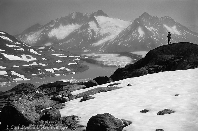
A backpacker stands, naked, in the Chugach Mountains, Wrangell-St. Elias National Park and Preserve, Alaska.
Hey Folks,
“It can be a difficult journey to live a creative life, if you live within an environment which does not understand or value creativity. Seek-out and surround yourself with positive soulmates”.
I read this note on a Status Update on facebook a while back, posted by a great photographer from Australia, Steve Coleman. Steve posts consistently valuable stuff on his facebook page, and I try to read every one of his insights. It’s nice to see someone so giving of their talent. I’ve never met Steve, but looking over his website I can tell you I already know I like the guy; click on ‘Workshops‘. That page tells me all I need to know; what a wonderful perspective!
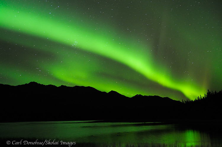
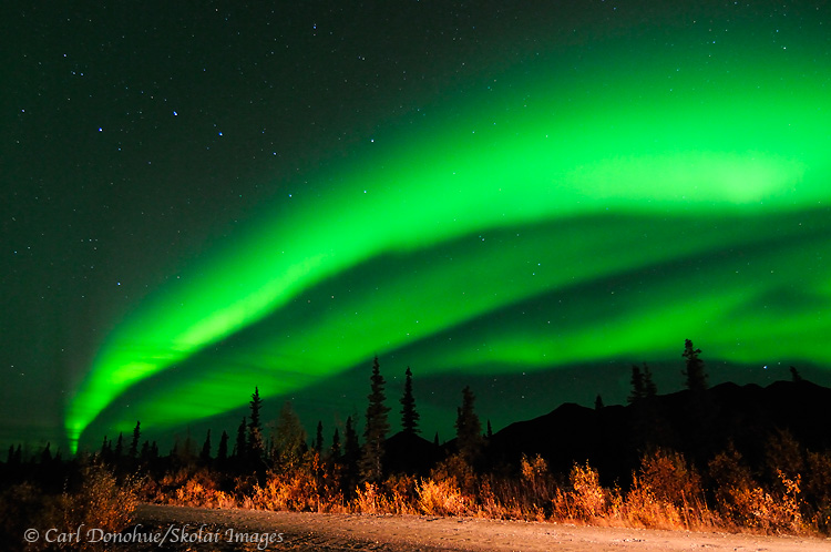
The aurora borealis (northern lights) light up the night sky and a reflection glows in the lake in the Mentasta Mountains, boreal forest, Wrangell-St. Elias National Park and Preserve, Alaska.
Hey Folks,
Here’s another northern lights photo from Wrangell-St. Elias National Park. This one I tried my darndest to catch the reflection in the foreground, but the slight breeze thwarted my every effort.
I’m seriously considering buying the Nikon 24mm 1.4 lens, specifically for northern lights photos. The difference in shutter speed with that lens, versus using a 2.4mm lens, is enormous.
For example, this northern lights photo was taken at f.28 and a shutter speed of 25 seconds. That means after the exposure, is then need to let the camera effectively take another 25 second exposure for noise reduction .. meaning the total time elapsed is 50 seconds. That’s a lot of time to be not shooting. it also means, with that long exposure, the lights tend to wash out a little, and lose definition that comes with a faster shutter speed.
Conversely, if you happen to be suffering from Strep throat induced diarrhea, the longer exposure can work to your benefit; you’ll certainly not be in any rush for the camera to finish doing it’s business while you tend your own. Just say’n, cause trust me, it CAN happen! 🙂
On the other hand, a lens with max aperture of 1.4 is 2 whole stops faster ..
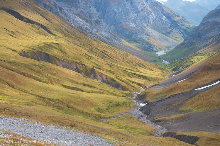
Hidden Creek valley, in the Wrangell mountains. A popular backpacking route, Hidden Creek in the Wrangell Mountains over to the Lakina River is a wonderful hike. Wrangell-St. Elias National Park and Preserve, Alaska.
Hey Folks,
I’ve headed out again for the next trip, but will schedule this post in advance. This is from close to the pass above Hidden Creek, looking back down the valley we’d just hiked. We walked up the south side of the valley (right side in the frame), then crossed and climbed up to a bench on the north side of the pass. Camping up there was simply awesome. 2 bands of Dall sheep were wandering the mountains above us, and we saw mountain goats higher still.
Hidden Creek is simply stunning. This particular afternoon, we crested the pass and camped on the other side of the saddle, which is where the previous post’s photo (“Reflections”) was taken. Suffice it to say that the back half of the trek is just as rocking as the front half.
Aurora borealis photo. Using my vehicle headlights to light up the foreground a little bit. Northern lights, Wrangell-St. Elias National Park and Preserve, Alaska.
Hey Folks,
An aurora borealis photo taken a few weeks ago.
I’ve never had the good fortune to shoot the aurora borealis on a well lit night; a clear night when the moon is full, or close to it, would be ideal. My luck always seem to run into a dark night, which makes for a great, great experience, but the photographs could benefit from some ambient light on the foreground.
So, in this particular instance, I turned on the lights of my van for a split second during the exposure. It took me a couple of tries to get the balance right, and it’s far from ideal, but I kind of like this shot; taken along the Nabesna Road in mid-September.
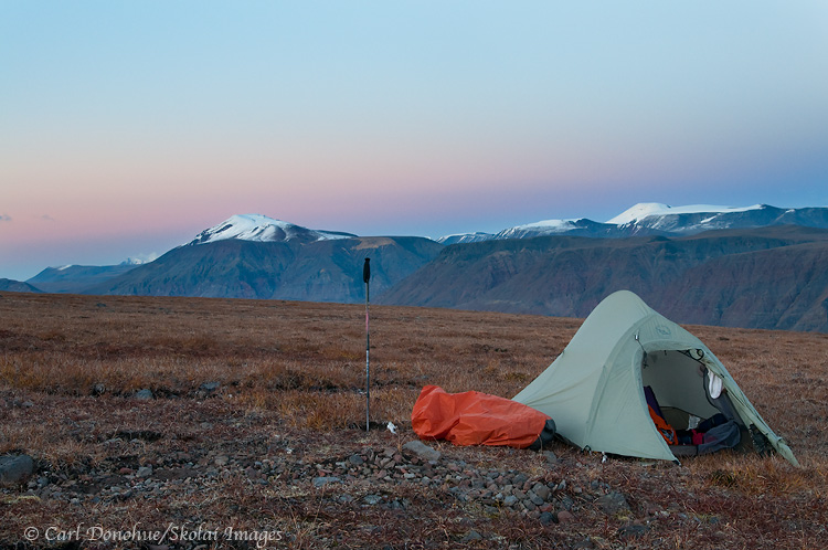
A backcountry campsite (Big Agnes Seedhouse SL1) high on the tundra in the Wrangell Mountains. The high alpine ridges near Mt Jarvis, Wrangell-St. Elias National Park and Preserve provide a great place for hiking and backpacking.
The Trip: Backpacking Near Mt Jarvis in Wrangell-St. Elias National Park
Just to stave off the impending deluge of grizzly bear photos, I thought I’d drop this one in here. This is from the last backpacking trip of the season for me, the recent Mt Jarvis excursion. Here’s a campsite I picked out all by myself, high on the tundra.
With a night so wonderfully clear, the temperatures dropped down a bit during the evening, and it was plenty cold in the am when I awoke before dawn, and sauntered across the tundra to ‘reflection pond’, where I shot some of the recent images posted of Mt. Jarvis.
Weight and Packability
For this trip, I carried the Big Agnes Seedhouse SL1 tent that you see here. It’s a nice little 1 person tent, pretty roomy actually, and relatively light. Weighing under 3lbs,
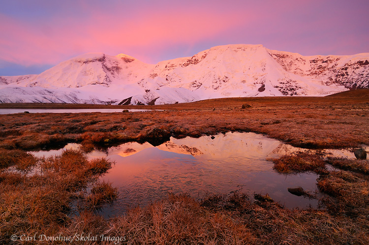
Dawn rises over Mount Jarvis, alpenglow lighting the mountain and it’s reflection. Fall, Mt. Jarvis, Wrangell-St. Elias National Park and Preserve, Alaska.
Mt Jarvis, in all it’s 13 421′ glory.
A recent trek up around the Mt Jarvis area yielded some amazing scenery and fantastic views. I hadn’t been to the area before, and will definitely be heading back next year. To camp within a few hundred yards of this mountain face is a treat indeed. We were pretty lucky, for sure, considering we were camped at about 7200′ in the Wrangell Mountains in September!
We had a real mix of weather, from snow storms and rain to gorgeous sunny days; which I’ll take gladly. The trek was a lot of fun, with a great couple from Chicago, Brad and Tracey. I appreciated their flexibility and easy going nature, which allowed me to sneak out a morning or 2 and grab some photos. Tracey joined me once or twice, and both Brad and Tracey got up early on our final morning to make a a mad dash out the Nabesna Rd in the hopes of snaring some nice alpenglow on Mt Sanford. Much appreciated, Tracey and Brad. What a gorgeous morning that turned out to be.
Reflections in the morning, of fresh snow or termination dust on the Wrangell Mountains, near Mount Blackburn, Wrangell-St. Elias National Park and Preserve, Alaska. Please click on the image to view a larger version of the photo.
Hey Folks
Here’s another image, taken earlier, of the scene outside my tent door a few mornings ago. After spending the previous day in the rain, cold, sleet and snow, I went to bed hoping for an improvement in the weather.
All during dinner, I had watched the snowline on the peaks above camp come ever slowly down the mountains – lower and lower. Now, listening to the rain fall on my tent, I didn’t imagine much change happening.
Turning off my headlamp, it was lights out, and I had barely a flicker of hope for the rest of the hike – the continuing patter of rain falling on my tent a sound I was about done with. Eventually that sound faded and then ceased altogether – at first I thought it had simply turned to snow, but a glance outside confirmed that nope, the rain had actually stopped. Woo hoo!
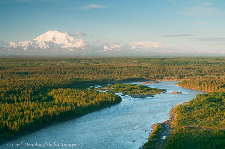
The Copper river and Mt Drum, from Simpson Hill Overlook. View of the Copper River basin and Wrangell Mountains, Wrangell-St. Elias National Park and Preserve, Alaska. Please click on the image thumbnail to view a larger version of this photo.
Hey Folks,
OK, enough with the waterfalls already! Here’s another image from my spring trip earlier this year, from Simpson Hill Overlook, off the Richardson Highway, near Glennallen, Alaska. This is a scene I’ll never tire of; looking down the Copper River, with the Wrangell Mountains in glorious sunshine. The mountains you can see in this image are Mt. Drum on the left and Mt. Wrangell the broader, dome-shaped mountain on the right in the background.
Just out of sight to the left of the frame is Mt. Sanford, and Mt. Blackburn to the right. How many vantage points do you know of in North America where you might choose to exclude from your photo two mountains both of which stand over 16 000′ high? That speaks volumes, in my opinion, about how amazing this viewpoint is. The 5th (Blackburn) and 6th tallest peaks (Sanford) in the US and they don’t make the photo? Craziness!
The Copper River is pretty grand too. Not to get bogged down by meaningless numbers and superlatives, but the Copper River is 300 miles long, and the 10th largest river, by volume, in the US. The Copper River is also the north and western boundaries of Wrangell-St. Elias National Park and Preserve, coolest park in all the world! It’s perhaps best known, however, for its nearly infamous Red Salmon run, usually over 2 million spawning salmon, loaded with fatty Omega-3 oils that make for some delicious supper.
I was really hoping for some sweet delicious alpenglow on this particular evening …. but ….. alas, such wasn’t to be my fortune. The light faded soon after I shot this – the boreal forest in the foreground grew dark, and the mountain light ebbed and dwindled; distant dim clouds low on the northwestern horizon thwarted my efforts at capturing some rich color on the snow-capped peaks, as seems to be the case all too often.
This scene is one of the very few ‘roadside‘ vantage points from which to photograph some of the big mountains in Wrangell-St. Elias National Park and Preserve. Willow Lake is another. The views on a clear day from these places rival anything I’ve seen anywhere else. The problem, I guess, for photographers is that the clear days are few and far between. Enjoy ’em when ya can! 🙂
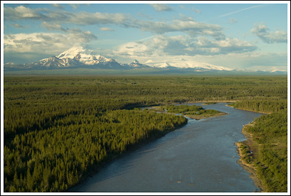
Copper River and Mt. Drum, Wrangell St. Elias National Park, Alaska
Copper River and Mt. Drum, Wrangell St. Elias National Park, Alaska.
Hey Folks,
Here’s another image taken from Wrangell St. Elias National Park. This scene looks towards the park from the national Park boundary, the Copper River. Mt Drum and the Wrangell mountains oversee the immense Copper River Basin providing an incredible backdrop to this vastness. The Copper River is one of the largest rivers in Alaska, and also, like all large rivers, critical to the life and cultures of the ecosystems existing around it. The Copper River actually starts out on the east side of these mountains, on the Copper Glacier, which runs off Mt Wrangell.
Mt Wrangell is visible in this photo as the broad almost flat snow-covered peak rising directly above the island in the river. As this scene is taken from the north west corner of the park, it’s clear the river wraps around the mountain, starting on the east side, running north then west, then eventually running south, forming the western border of Wrangell-St. Elias National Park, all the way down through the Chugach Mountains, the Chugach National forest, forming the huge Copper River delta, and emptying into the Gulf of Alaska. The Copper River runs about 300 miles, or nearly 500 kilometers, from its beginnings in the Wrangell Mountains until it reaches the coast.
The Copper River has been important to people in the area for many years, for many reasons, but is primarily known today for the red salmon that run up it every summer to spawn. Copper River Reds, as they’re known, are widely regarded as some of the tastiest salmon in the world. They’re also known as Sockeye Salmon.And they sure are tasty!
The views towards the park from the Richardson Highway are as fine as they salmon that swim up the river are tasty. From various overlooks, it’s possible to see 4 mountains all standing over 12 000′ high, including 2 peaks over 16 000′ (Mt Sanford and Mt Wrangell). The Wrangell mountains are as impressive as any I’ve seen. Great photo opportunities can be found right off the highways (Richardson and also the Glen Highway), weather permitting, of course. These are all volcanic mountains, and have some dramatic features, Mt Drum, from the south side, is simply stunning.
Copper River in Winter
Simpson Hill Overlook
View of Wrangell-St. Elias National Park and the Copper River.
Here’s a photo I took last spring, just at start of the season Alaskans call “breakup”. This photo is taken from the roadside overlook just south of Glennallen, at Simpson Hill. Simpson Hill is rapidly disappearing, as the Copper River (in the foreground) erodes and cuts away at its base. Soon enough the spot may be known as “Simpson Mound”.
This is probably one of the very few (maybe 2) iconic view spots for the Wrangell Mountains and Wrangell-St. Elias National Park, the largest (and way coolest) National Park in the US. There are certainly many other grand views to be had, and amazing sites, but few that are so frequently photographed from.
The mountains, viewed from this spot, are simply awesome. From left to right, the mountains are Mt. Sanford, Mt. Drum, Mt Zanetti and Mt. Wrangell. Mt. Sanford is the highest of the 4, at 16 237′ tall. Next up is Mt. Wrangell, the broad round massif on the far right, at 14 136. Mt. Zanetti, the little “ski jump” looking cone that springs off Mt Wrangell, is 13 009′ tall, and Mt. Drum, front and center, is just over 12 thousand feet, at 12 010′ high. Those are some grand mountains. Most of the boreal forest in the foreground is white spruce, though there’s a cool band of aspen or poplar in the middle of the frame that can add a vibrant yellow to this scene in the fall. The mighty Copper River, defines the border of the National Park, running south to delta where it runs into Prince William Sound near Cordova. It’s fascinating to see how the river changes throughout the year, raging a turbulent, roaring silt-laden brown in early and mid-summer, clearing up through late fall as it’s volume decreases to a crystalline turquoise, to a frozen, ice-covered mystery in the winter.
It’s a magnificent viewpoint, and it’ll be interesting to see how it changes in the coming years, with the Copper River eating away so readily every summer. I was there last weekend, again, and noticed it’s even eroded further back than it was in the spring.
Note to visitors: If you DO perchance go to Simpson Hill to get this perspective on Wrangell St. Elias National Park and the Wrangell Mountains, I’d recommend parking in the paved parking lot, and walking the 100 yards or so back over to the edge .. driving over the little gravel road/trail to the edge can easily get you bogged and stuck, as the soil there is way muddy, and your tires can readily sink into it’s greasy depths. Not that this ever happened to me, of course .. 🙂 … but it can happen . so be careful up there. And hope you get some nice light. It’s a great vantage point in the evening.
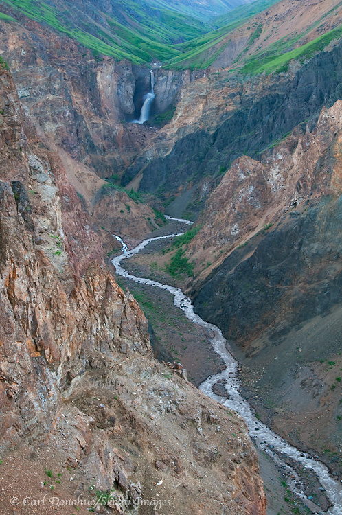
Chitistone Falls, in the Chitistone valley. The Goat Trail is a popular backpacking route, from Skolai Pass to Glacier Creek, along the Chitistone River, in Wrangell-St. Elias National Park and Preserve, Alaska. Please click on the thumbnail to view a larger version of this photo.
Hey Folks,
Chitistone falls are one of my favorite waterfalls in the entire park yet I rarely get to see them.
How do you get to Chitistone Falls?
I usually backpack down from Skolai Pass. It’s possible to approach from the west if you’re coming up Chitistone River, or even from the north if you can up Doubtful Creek from Nizina Lake.
When I do the Goat Trail now, I head north after crossing the scree slopes, and go away from the Chitistone river, rather than down lower toward the river, which is the only way to view the falls.