hey Folks,
Here’s another photo from the nice evening we got at Ross Green Lake. As the last of the light faded, I headed up over this small ridge to this patch of dwarf birch that I had found earlier in the afternoon. The red brush is the Dwarf Birch (Betula borealis) – a spectacular bush in the fall – it’s pretty hard to hike through, though – not much fun at all. But how it redeems itself in the fall – what a beautiful plant. Now if only we can do something about that alder. 🙂
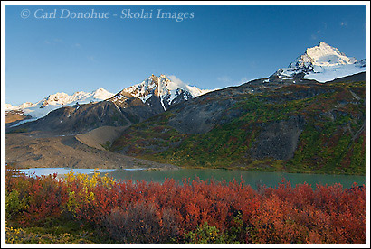
In case you didn’t see the earlier post, this is Ross Green Lake and Thompson Ridge in the background.
Cheers
Carl
What a beautiful place! I could daydream for hours there. You’ve gotten some awesome pics this year. And I’m sure there are more to come. Even with the on & off bad weather, you’ve gotten some wonderful stuff!!Stay safe, as always!!
P.S.- I can clearly see the knife edge ridge in the background. What is the difference between a ridge & moraine? Or is there any? Hey, I know it sounds like a dumb question, but if you never ask how are you going to know the answer? Thanks!
Hey Beth,
Thanks for the posts and the kind words.
A moraine is, essentially, a pile of rocks left over by an advancing or retreating glacier. The glacier scours out the earth as it crawls forward, and that debris is deposited in the form of rocks, large to small, usually in a linear pattern. You’ll find 3 typical moraine patterns:
A medial moraine, which runs down the middle of a glacier or at the junction of 2 glaciers, a lateral moraine, white runs along the edges of a glacier, and the terminal moraine, at the end of the glacier.
A ridge is really an escarpment, or exposed uplift. In the above, the moraine is the pile of rocks in the lower left hand corner, with the sweeping curve to it. That would be the lateral moraine. Thompson Ridge is the line of high jagged peaks in the background.
I hope this helps explain it. I’ll try to post some images later that might be a little clearer.
Thanks.
Cheers
Carl
Boy, I am sure glad Beth asked what the Moraine was. 🙂 (I didn’t know either)
Couldn’t ask for better foreground elements here Carl. Sweet.
Hey Mark,
Thanks for the kudos.
As for the moraine, I should’ve explained it better. There’s a glacier here, coming down between the first snow covered peak on the right hand side of the photo, and the 2nd snow covered peak in the middle (there’ actually glaciers coming down between each of the snow covered peaks, but we’ll just consider this main one). The glacier has worn down the rock between what are now 2 peaks, carving a “Hanging Valley” out. As the ice has swung down from the higher peaks, it pushes all that rock and earth out of it’s way. Think of pushing your first through sand at the beach. You’ll see sand deposits in three places:
1) at the end of your fist (equivalent to the terminal moraine)
2) on either side of your fist (the ‘lateral moraines’), and
3) between your knuckles, coming back up over your fist (the medial moraines)
What we’re seeing in this photo is the lateral moraine, the long sweeping curved line of rock coming out of the valley and heading towards the lake shore. Then all the rock below that is probably the terminal moraine, or parts thereof.
I hope that helps a bit more. I’ll look for some ‘moraine photos’ to post soon.
Cheers
Carl