Category Archives: Alaska

Photos and notes on all things Alaska.

Wrangell mountains and winter’s release

Stairway Icefall and Donoho Peak, Wrangell-St. Elias National Park and Preserve, winter, Alaska.
Winter snow covers Kennicott Glacier and alpenglow catches the peaks of the Wrangell Mountains and Stairway Icefall, Wrangell St. Elias National Park and Preserve, Alaska.

Hey Folks,

The Wrangell Mountains in winter. Alpenglow catches the eastern edge of the range. This view is looking up the Kennicott Glacier. At right is the edge of Bonanza Ridge, Jumbo, Then Stairway Icefall, Donohue Peak just left of center, and the Ahtna Peaks behind that to the left.

Winter’s finally wrapping itself up here in the north; it lingers much as the sun’s final rays cling to these high peaks at days end. Spring makes it’s way north slowly, and and is completely diurnal for now. The days, growing longer weekly, yield. But the night belongs to the winter, the cold, dark silence of the quiet time.

This is the first real “view” I ever had in Wrangell-St. Elias National Park and Preserve, all those years ago when I first ventured north on a backpacking adventure. I’d taken a bus from Fairbanks south, and the weather wasn’t so great; not raining, but overcast. I didn’t really have any idea of the scale of the landscape I was amongst at the time. The bus dropped me off on the highway, at the Edgerton Cutoff, and I hitch-hiked from there in to McCarthy (about 90 miles). That was an adventure in itself, maybe I’ll recount it another time.

Continue reading

Bridge to Nowhere – Gilahina Trestle, Wrangell-St. Elias National Park.

The Gilahina Trestle fades into winter, Wrangell-St. Elias National Park and Preserve, Alaska.

Alaska’s Ultimate Bridge to Nowhere – The Gilahina Trestle fades into winter, Wrangell-St. Elias National Park and Preserve, Alaska. Click for larger version.

Hey Folks,

The Gilahina Trestle, crossing the Gilahina River, was once an impressive structure. Built in 1911 as part of the Copper River and Northwestern Railway (nicknamed “Can’t Run and Never Will”), the Gilahina Trestle was not quite 900′ long, and nearly 100′ high. Rumors say that it took less than 8 days to build, and the first train ran across its length on January 28, 1911. It’s since fallen into some disrepair, as is evident from this image. It’s a rickety ole job, at this point, and walking across it with nearly a foot of snow covering each board was, uhhm, sketchy. But I made it out for a few photos and back in one piece.

The Gilahina Trestle is now listed on the National Historic Register, which means it’ll probably come in for some funding to repair/restore it.

Continue reading

Blurred Aspen boles

Camera panning blurs the boles of Quaking aspen (Populus tremuloides) in Wrangell-St. Elias National Park and Preserve, Alaska.

Camera panning blurs the boles of Quaking aspen (Populus tremuloides) in Wrangell-St. Elias National Park and Preserve, Alaska.

Hey Folks,

Here’s a follow up to the post below of this small aspen stand in Wrangell-St. Elias National Park and Preserve. Aspens aren’t doing so well in the warming climate we’re seeing in the world today. It’s more than a shame, they’re such a magnificent tree.  I remember the first time I ever camped beneath the canopy of a stand of aspen, not far off the Resurrection Pass Trail in Alaska’s Kenai Peninsula. A quick dinner of pasta and tuna, some cocoa and a Milky Way for dessert, and my sleeping bag called my name; just as I settled in to that beautiful state of semi-consciousness between wakefulness and sleep, those moments when all the world is your friend, a slight breeze rustled through the forest, the indescribable sound instantly hooking my complete attention.

Continue reading

Fall Colors in the Taiga

Fall colors glow in the boreal forest, Wrangell-St. Elias National Park, Alaska.

Hey Folks,

While I’m out trudging around in the cold and wet mountains, you get to sit home and read about it, and still see the pictures!

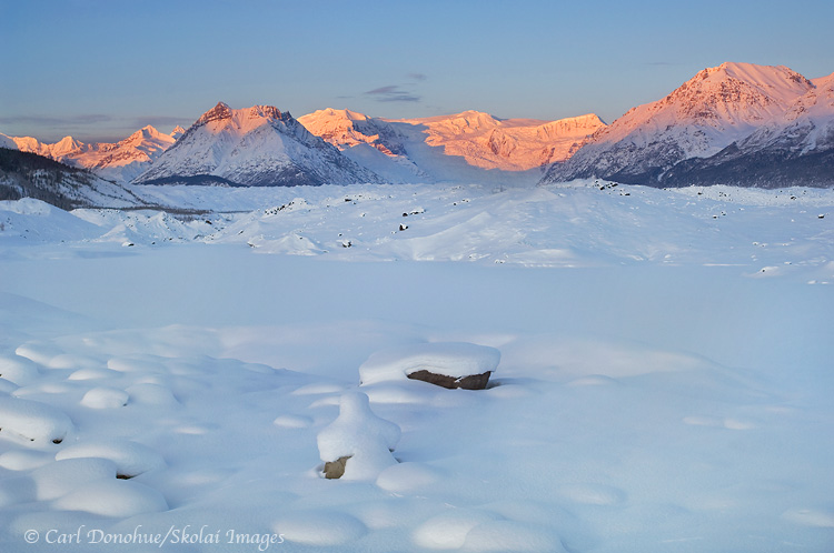
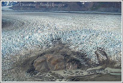
This photo was from my recent trip to the north side of Wrangell-St. Elias National Park, off the Nabesna Road. The weather wasn’t super co-operative for grander landscape images, which was a bummer, as there are certainly some grand landscapes to be had in the area. But the weather was good for more intimate scenes, like this one.

The boreal forest is a real treasure, and hiking through it is always a treat. It’s amazing what one can find sometimes – I’v e found everything from moose racks  and caribou racks  to trekking poles, tent stakes and other trash. But this last trip was a first for me. I found a fully-loaded, good condition large caliber centerfire rifle, with a scope, sitting by a tussock in the forest. I packed it out, and handed it in to the Park Service office, and still haven’t found out exactly what happened as to how the rifle came to be there. Pretty crazy stuff.

Other than my trip was,  as always, too brief. Marred by dismal skies, I was really hoping to get some big shots of Mt Sanford, but the mountain was only rarely visible. The final morning of my trip it was out, but distant clouds to the east blocked the sun’s rays from adorning the peak – total bummer. There is a view of the mountain that I think lends itself to as fine a landscape image of grand mountains as any, but I need to put in more time, apparently, to make it happen.

As for the image above,  I spend so much of the summer hiking and trekking in the alpine areas of the park that I don’t get to spend the hours in the forest that I would like. The forest is a special place, and I always enjoy my time there. In the fall, it comes alive with color, and this year was grand, for sure. The color seemed to peak around the end of August, and only a few days later had  noticeably dropped off. I was lucky to catch it before that happened.

I’ll be back (hopefully) from my next trip with some more landscapes, and then we’ll see what the last 2 weeks of September bring for my trips. At the moment, I’m toying with a few ideas, but haven’t set anything in stone so far. We shall see.

Oh, a side note; this kind of more open boreal forest is often referred to as ‘taiga’, which is a so-called Russian word for ‘little sticks’,  expressing the smallish stature of the spruce trees. However, my Russian friend Sergei tells me that in Russia, the word taiga simply means ‘forest’. We’ll have to explore this controversy further and see wherein the truth lies. In the meantime, here’s a quiz; how many various vegetation species can you see here, and what are they (Mark Vail you go last)?

Cheers

Carl

Mount Sanford, Wrangell-St. Elias National Park

Mount Sanford, Wrangell St. Elias National Park, Alaska.

Hey Folks,

This is a photo of Mt Sanford, in winter, taken early one morning. In 2 weeks I had 3 mornings with some alpenglow. The first one I didn’t shoot because it was so socked in with cloud an hour before dawn that I didn’t figure the light was going to happen – and being tired, I slept in. I awoke, looked over, and saw a nice magenta glow on the face of Sanford, but there wasn’t really any kind of way to shoot it from where I was. Such is my life, it seems. I did enjoy a hot coffee and

Continue reading

Winter in McCarthy

2 Winters in McCarthy from an Aussie Photographer

Spending winter in McCarthy is a study in both extreme beauty and quiet endurance. Life in Wrangell St. Elias National Park during the coldest months revolves around the simple mechanics of survival, like hauling wood for the shack or coaxing a frozen snowmachine to life.

While most people only see this landscape in the green of summer, the true character of the backcountry emerges when the crowds vanish and the mercury drops toward minus fifty. The mountains seem to pull closer in the crisp air, and the vast silence is only broken by the occasional crunch of skis on fresh powder.

The following collection of images and stories comes from my time poking around the frozen Kennecott River and the Lakina drainage.

Whether it is chasing the magenta alpenglow on Mt. Porphyry or hunting for abstract patterns in the snow covered glacial moraines, winter photography here is a constant battle against the elements. Everything from sticking tripod legs to fogged viewfinders makes each frame a hard earned reward. It is a slow, cold way of living, but catching that soft noon light on an unnamed peak makes every subzero mile worth the effort.

Livin in the a Little Shack Down by the River

A cabin in the woods in winter, Wrangell-St. Elias National Park, Alaska.

My humble abode. This is after I shovelled all the snow off the roof. There’s about another 6-9 inches of snow on the roof already!

Continue reading

Bald eagle, Alaska

Bald eagle, catching a fish, Kachemak Bay, Homer, Alaska.

Hey Folks,

Just as a head’s up – unfortunately, my posting here is about to slow down considerably. I, apparently, have a great deal of work to catch up on. And I was hoping, if things worked out well, I’d have some good internet time in the next few months .. but that appears to be unlikely now. I’ll try to keep posting here as possible, it’ll be a little slower for a while, I think. Bummer, eh?

In moving along with my ‘showing some older, pre-blog-photo-era images, I thought I’d post a bald eagle image. This is from the winter of 2002. Continue reading

Twaharpies Mountain Range, Wrangell-St. Elias National Park, Alaska

Twaharpies Mountain Range, peaks, sunset, Wrangell-St. Elias National Park, Alaska.

hey Folks,

Here’s another image from a few years ago – on a trip to Wolverine, a ridge high above the Chitistone River in Wrangell-St. Elias National Park, Alaska. The Twaharpies Mountains lie south of the ridge, across the river, and came out late this evening with some gorgeous light. The peaks are pretty cool – classic alps. Just east of this peak lie the University Range, home to Mount Bona and Mount Churchill.

Wolverine is a local name for the (officially) unnamed ridge on the north side of the Chitistone River, and a great spot for a basecamp or a point to point hike – I usually hike from Skolai Pass west to Wolverine, but some folks like to do it in the other direction. It’s a classic alpine walk, through some of the most magnificent scenery I’ve ever stumbled my way through. There’s a crazy butte on the north side of the ridge, like something out of the desert southwest, but all around are jagged craggy peaks, like the Twaharpies.

Maybe I’ll continue on with a short series of images from years gone by, rather than continually posting new photos. This counts as 2. 🙂

Cheers

Carl

Tana Glacier, Wrangell-St. Elias National Park, Alaska

Broken calving ice at the terminus of the Tana Glacier, near the Bagley Icefield, Wrangell-St. Elias National Park, Alaska.

Hey Folks,

Here’s another aerial photo I took, right before we landed at Ross Green Lake. This is the terminus of the Tana Glacier. This glacier sits just northwest of Mount St. Elias.

It used to be possible to hike from Ross Green Lake, east of here (to the left) across the glacier, and around to Iceberg Lake. As you can see from this photo, the Tana Glacier has become an array of crevasses – not something one can easily, or safely, hike across.

The route hasn’t been hiked in a few years. I wish I had an opportunity this trip to explore it a little more, and possibly find a new route across. It looked to me, from the air, like it was possible slightly to the north of here, but I can’t say without hiking it first, or at least a good look from the ground – from the air, in a place as vast as this, perspective is everything, and things are often not as they appear to be; the scale is so hard to gauge.

I like the story this photo tells – of the place of ice and water on rock, and how this stuff works. Look at the rock in the foreground, and the debris surrounding it, torn, cracked, splintered and shattered by power of the ice and a little gravity. In the background, you can clearly see a medial moraine, running down between the seam of 2 glaciers that run together off the great Bagley Icefield to create the Tana Glacier.

I did get to hike, one afternoon, down from our camp to the Tana Glacier and walk around it a bit. it’s amazing being on the ice. I’ll post some photos from that hike later.

Cheers

Carl

Hubbard Glacier Photo, Wrangell-St. Elias National Park, Alaska

Hubbard Glacier and Disenchantment Bay, Wrangell-St. Elias National Park, Alaska.

hey Folks,

Well, this one is not from our last trip. This photo is of the Hubbard Glacier, from my trip in June down to SouthEast Alaska. The Hubbard is a well-known glacier, because it’s one of the most calvingest glaciers in the world. The Hubbard Glacier is over 70 miles long, reaching from it’s beginnings along the face of Mt. Logan, all the way to the Pacific Ocean, at Disenchantment Bay and the Russell Fjord. Lots of cruise ships pull in for a view, but because of the abundant icebergs in the bay, they keep their distance. Icebergs the size of a 10-story building frequently fall from the face of the Hubbard Glacier, not something one wants to be to close to.

Continue reading