What’s your page rank? How many friends do you have? Retweets? Have you shared anything today? What’s your title tag? Incoming links? How’s your website rank?
Now that summer is over, and it’s officially “office season”, you’re probably spending your time doing much of what I’ve been doing lately; website work, photo editing, marketing and promotion via the sticky, tricky and infinite webs we call SEO (Search Engine Optimization) & Social Media (making me wonder what, exactly, Anti-social Media might be).
SEO is a pretty tricky beast. It’s a lot of research, reading, re-reading, web-coding, overhauling, reviewing, more research, re-coding and hair pulling. It’s mostly a lot of trial and error; it’s not a given, for example, that what works for one site is applicable and relevant for another. And it’s almost certain that what works on the article you just carefully absorbed will not work on your website. So, it’s mostly guesswork.
Sometimes the results are what we hoped for, and we pat ourselves on the back, and think how clever we are. Sometimes, despite all out best efforts, the old googles kick our superbly optimized page to the bottom of page 11 on their results; this really hurts when you see some trashy, 1993-styled geocities looking webpage showing up on the first page of rankings.
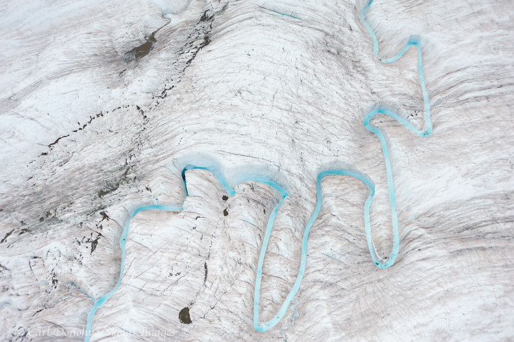
Glacial Stream and ogives, Root Glacier, Wrangell-St. Elias National Park and Preserve, Alaska.
Hey Folks,
From my most recent trip to Wrangell-St. Elias National Park and beyond. This is an aerial photo from above the Root Glacier, near Kennecott and McCarthy, Wrangell-St. Elias National Park and Preserve. The small stream is made up largely of runoff water from Stairway Icefall, a massive 7000′ vertical wall of ice that effectively form the “headwaters” of the Root Glacier.
This is an image I’ve wanted to capture for sometime now; I’ve seen various similar images of this same stream from a few photographers, including my friend Ron Niebrugge, and often thought it would be a cool subject to shoot. Indeed it is.
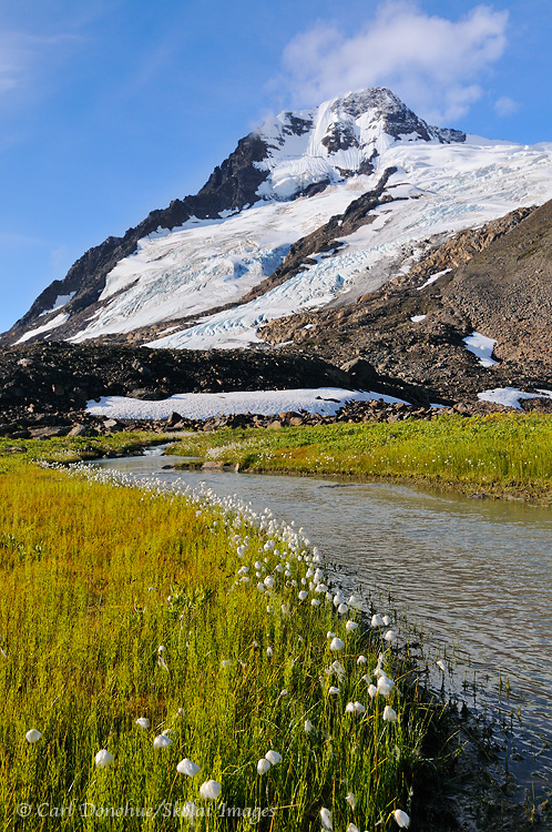
Alaska Cotton, and glacier, near Iceberg Lake, Wrangell-St. Elias National Park and Preserve, Alaska. Please click on the image above to view a larger version of this photo.
Hey Folks,
We just got off a great hike in the Chugach Mountain Range, Wrangell-St. Elias National Park; the Iceberg Lake to Bremner Mines route, a popular hike I’ve done a number of times now. This trip was an exciting adventure, as always, with a mixture of weather, some great folks to hike with, tons of cool stuff to see.
We actually took what is for me a new route part of the way, and skipped one of the climbs; heading straight for a glacier moraine and on to the ice instead. That was kinda cool, and I did find a great spot to camp that I hadn’t been to before, which is always a treat.
December 6, 2010, marks the 50th anniversary of the establishment of the Arctic National Wildlife Refuge, or ANWR, in Alaska. To commemorate this, and as a tribute to an amazing place, I’ve put together this slide show; 50 photos to mark the 50 years. These are all images from the Refuge, over 19 million acres of wild lands. The refuge is a treasure, home to thousands of creatures and features; the caribou herds, the Brooks Mountains, the broad coastal plain, migratory birds and countless other gifts to this world. A beautiful landscape that warrants our respect, not our exploitation.
I selected the images to present a the diversity of features and creatures that call the Refuge home, and composed and recorded the music to accompany it. I hope you enjoy it.
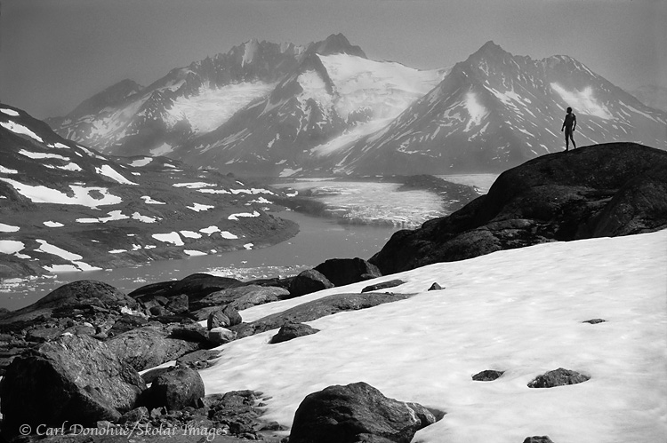
A backpacker stands, naked, in the Chugach Mountains, Wrangell-St. Elias National Park and Preserve, Alaska.
Hey Folks,
“It can be a difficult journey to live a creative life, if you live within an environment which does not understand or value creativity. Seek-out and surround yourself with positive soulmates”.
I read this note on a Status Update on facebook a while back, posted by a great photographer from Australia, Steve Coleman. Steve posts consistently valuable stuff on his facebook page, and I try to read every one of his insights. It’s nice to see someone so giving of their talent. I’ve never met Steve, but looking over his website I can tell you I already know I like the guy; click on ‘Workshops‘. That page tells me all I need to know; what a wonderful perspective!
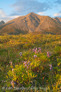
A small bloom of Arctic Lupine in the Brooks Mountain Range catch last light of the summer day. Land of the midnight sun, the Arctic National Wildlife Refuge, or ANWR, in arctic Alaska where the coastal plain meet the Brooks Mountain Range.
Back in September the US F&WS (Fish and Wildlife Service) announced, as part of their Comprehensive Conservation Plan, that “the Service will conduct wilderness reviews for three Wilderness Study Areas (WSAs) for potential inclusion within the National Wilderness Preservation System. These three WSAs encompass almost all refuge lands not currently designated as wilderness”. This is good news. I’ll reiterate my favorite part of the quote: “These three WSAs encompass almost all refuge lands not currently designated as wilderness“.
There are numerous steps involved, and, if recommended by the US F&WS, approval is required by the Dept Director, the Secretary of the Interior, and the President. Then, the final decision lies with the US Congress; the actual authority to designate land as ‘wilderness’.
It’s almost comical, really and I’ve written at length on the issue of conserving the refuge. But such a rigorous and formalized process to meander through in order to deem lands “wild”. Implicit in the word wild is ‘free will’ – yet not quite so wild as to be free of the rigmarole of official procedure, of course.
Anyone who suggests the 19 million acres of the Arctic National Wildlife Refuge isn’t a wilderness either hasn’t been there or is simply in denial. Perhaps I could say it more clearly this way; if the Arctic National Wildlife Refuge doesn’t qualify for ‘wilderness designation’, then we might as well remove that term from our vocabulary. Surely there is no place more deserving of such designation than the Refuge?
The “wilderness reviews” should be completed by Feb 2011, which will be followed by a released draft, more public comment, more revisions, and hopefully, a final plan and recommendation in May 2012. Apparently wilderness takes careful planning and review; it’s not simply created overnight.
A reminder that Dec 06, 2010, marks the coming anniversary of the establishment of the Refuge; I’m working on a little project for it, and should have it online soon. Stand warned. 🙂
Midnight sun on the coastal plain, Section 1002, near the Canning river. A small pond on the plain catches a the skies blue reflection. Pond and reflection, coastal plain, Arctic National Wildlife Refuge (ANWR), Alaska. Dec, 2010 marks 50 years since the federal government established the area as a national wildlife refuge.
Hey Folks,
Drill here? Drill now? I think not.
How about “Happy Birthday, and Cheers to the next 50 years!”
This year is the 50th anniversary of the establishment of the Arctic National Wildlife Refuge – “ANWR”, as folks like to call it. A swathe of wild land the size of South Carolina became a federally protected area in 1960, and then established as a wildlife refuge in 1980 with the passing of the Alaska National Interest Lands Conservation Act (ANILCA).
One of the most important conservation measures yet taken by this nation, the Act protects over 100 million acres of federal lands within Alaska; this single statute more than doubled the area of national park and refuge land in the country and tripled the area of federally designated wilderness. Roughly 40%, or 8 million acres, of the Arctic National Wildlife Refuge was (and is) designated wilderness. This one landscape makes up over 7% of the designated wilderness in the United States.
Next month, on Dec 6, 2010, ANWR turns 50 years old. Turn your thoughts northward, and give it a moment. Or several moments. 19 million acres of land this country gifted to itself. It’s a beautiful thing.
I’ve visited the refuge a number of times now, and each year the visit has been unimaginably rewarding. To those who’d rather see it turned into an oil well, I’d ask to what end?
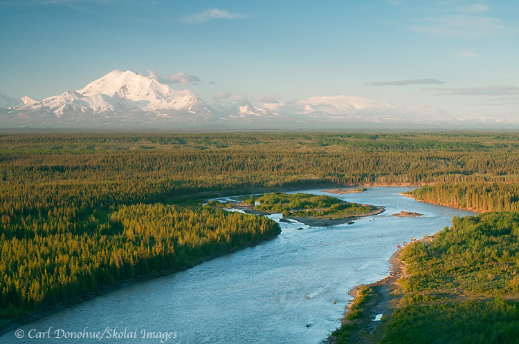
The Copper river and Mt Drum, from Simpson Hill Overlook. View of the Copper River basin and Wrangell Mountains, Wrangell-St. Elias National Park and Preserve, Alaska. Please click on the image thumbnail to view a larger version of this photo.
Hey Folks,
OK, enough with the waterfalls already! Here’s another image from my spring trip earlier this year, from Simpson Hill Overlook, off the Richardson Highway, near Glennallen, Alaska. This is a scene I’ll never tire of; looking down the Copper River, with the Wrangell Mountains in glorious sunshine. The mountains you can see in this image are Mt. Drum on the left and Mt. Wrangell the broader, dome-shaped mountain on the right in the background.
Just out of sight to the left of the frame is Mt. Sanford, and Mt. Blackburn to the right. How many vantage points do you know of in North America where you might choose to exclude from your photo two mountains both of which stand over 16 000′ high? That speaks volumes, in my opinion, about how amazing this viewpoint is. The 5th (Blackburn) and 6th tallest peaks (Sanford) in the US and they don’t make the photo? Craziness!
The Copper River is pretty grand too. Not to get bogged down by meaningless numbers and superlatives, but the Copper River is 300 miles long, and the 10th largest river, by volume, in the US. The Copper River is also the north and western boundaries of Wrangell-St. Elias National Park and Preserve, coolest park in all the world! It’s perhaps best known, however, for its nearly infamous Red Salmon run, usually over 2 million spawning salmon, loaded with fatty Omega-3 oils that make for some delicious supper.
I was really hoping for some sweet delicious alpenglow on this particular evening …. but ….. alas, such wasn’t to be my fortune. The light faded soon after I shot this – the boreal forest in the foreground grew dark, and the mountain light ebbed and dwindled; distant dim clouds low on the northwestern horizon thwarted my efforts at capturing some rich color on the snow-capped peaks, as seems to be the case all too often.
This scene is one of the very few ‘roadside‘ vantage points from which to photograph some of the big mountains in Wrangell-St. Elias National Park and Preserve. Willow Lake is another. The views on a clear day from these places rival anything I’ve seen anywhere else. The problem, I guess, for photographers is that the clear days are few and far between. Enjoy ’em when ya can! 🙂
Copper River and Mt. Drum, Wrangell St. Elias National Park, Alaska
Copper River and Mt. Drum, Wrangell St. Elias National Park, Alaska.
Hey Folks,
Here’s another image taken from Wrangell St. Elias National Park. This scene looks towards the park from the national Park boundary, the Copper River. Mt Drum and the Wrangell mountains oversee the immense Copper River Basin providing an incredible backdrop to this vastness. The Copper River is one of the largest rivers in Alaska, and also, like all large rivers, critical to the life and cultures of the ecosystems existing around it. The Copper River actually starts out on the east side of these mountains, on the Copper Glacier, which runs off Mt Wrangell.
Mt Wrangell is visible in this photo as the broad almost flat snow-covered peak rising directly above the island in the river. As this scene is taken from the north west corner of the park, it’s clear the river wraps around the mountain, starting on the east side, running north then west, then eventually running south, forming the western border of Wrangell-St. Elias National Park, all the way down through the Chugach Mountains, the Chugach National forest, forming the huge Copper River delta, and emptying into the Gulf of Alaska. The Copper River runs about 300 miles, or nearly 500 kilometers, from its beginnings in the Wrangell Mountains until it reaches the coast.
The Copper River has been important to people in the area for many years, for many reasons, but is primarily known today for the red salmon that run up it every summer to spawn. Copper River Reds, as they’re known, are widely regarded as some of the tastiest salmon in the world. They’re also known as Sockeye Salmon.And they sure are tasty!
The views towards the park from the Richardson Highway are as fine as they salmon that swim up the river are tasty. From various overlooks, it’s possible to see 4 mountains all standing over 12 000′ high, including 2 peaks over 16 000′ (Mt Sanford and Mt Wrangell). The Wrangell mountains are as impressive as any I’ve seen. Great photo opportunities can be found right off the highways (Richardson and also the Glen Highway), weather permitting, of course. These are all volcanic mountains, and have some dramatic features, Mt Drum, from the south side, is simply stunning.
Copper River in Winter
Simpson Hill Overlook
View of Wrangell-St. Elias National Park and the Copper River.
Here’s a photo I took last spring, just at start of the season Alaskans call “breakup”. This photo is taken from the roadside overlook just south of Glennallen, at Simpson Hill. Simpson Hill is rapidly disappearing, as the Copper River (in the foreground) erodes and cuts away at its base. Soon enough the spot may be known as “Simpson Mound”.
This is probably one of the very few (maybe 2) iconic view spots for the Wrangell Mountains and Wrangell-St. Elias National Park, the largest (and way coolest) National Park in the US. There are certainly many other grand views to be had, and amazing sites, but few that are so frequently photographed from.
The mountains, viewed from this spot, are simply awesome. From left to right, the mountains are Mt. Sanford, Mt. Drum, Mt Zanetti and Mt. Wrangell. Mt. Sanford is the highest of the 4, at 16 237′ tall. Next up is Mt. Wrangell, the broad round massif on the far right, at 14 136. Mt. Zanetti, the little “ski jump” looking cone that springs off Mt Wrangell, is 13 009′ tall, and Mt. Drum, front and center, is just over 12 thousand feet, at 12 010′ high. Those are some grand mountains. Most of the boreal forest in the foreground is white spruce, though there’s a cool band of aspen or poplar in the middle of the frame that can add a vibrant yellow to this scene in the fall. The mighty Copper River, defines the border of the National Park, running south to delta where it runs into Prince William Sound near Cordova. It’s fascinating to see how the river changes throughout the year, raging a turbulent, roaring silt-laden brown in early and mid-summer, clearing up through late fall as it’s volume decreases to a crystalline turquoise, to a frozen, ice-covered mystery in the winter.
It’s a magnificent viewpoint, and it’ll be interesting to see how it changes in the coming years, with the Copper River eating away so readily every summer. I was there last weekend, again, and noticed it’s even eroded further back than it was in the spring.
Note to visitors: If you DO perchance go to Simpson Hill to get this perspective on Wrangell St. Elias National Park and the Wrangell Mountains, I’d recommend parking in the paved parking lot, and walking the 100 yards or so back over to the edge .. driving over the little gravel road/trail to the edge can easily get you bogged and stuck, as the soil there is way muddy, and your tires can readily sink into it’s greasy depths. Not that this ever happened to me, of course .. 🙂 … but it can happen . so be careful up there. And hope you get some nice light. It’s a great vantage point in the evening.
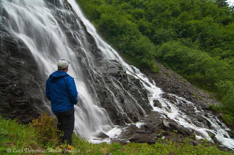
Exploring Keystone Canyon: Bridal Veil Falls and Horsetail Falls
If you are visiting Alaska and looking for a great drive, the trip south from Glennallen to Valdez is tough to beat. The route climbs south parallel to Copper River. Eventually it ascends up and over Thompson Pass in the Chugach Mountains and passes the Worthington Glacier before descending into the spectacular Keystone Canyon. This canyon was first used as a route for a train line to the interior gold mines, and you can still see the old tunnel built nearly a century ago.
The Lowe River runs through the bottom of the canyon, creating a dramatic backdrop for two of the most famous waterfalls in the region. While many people search for these names in California, the Alaskan versions in Keystone Canyon offer a much more rugged experience.
This route parallels the nearby Copper River.
Finding Stillness, Horsetail Falls
Standing alongside Horsetail Falls, near Valdez, on the Richardson Highway, Alaska.
Here’s a photo from my trip down the Richardson Highway – Memory Lane.
This one is Horsetail Falls, another waterfall in Keystone Canyon and the Lowe River, just south of Bridal Veil Falls, (that image is posted below).
Waterfalls are so cool; I can sit and stare at a waterfall for hours, it seems, never tiring of the flow. The energy of the falls is often spellbinding.
I first visited this particular area, along the Lowe River in Keystone Canyon, on a trip to Valdez in 2000. That trip seems like several lifetimes ago now. It rained most of the time, and I left soon after, heading north to Wrangell-St. Elias National Park for a backpacking trip. I wish I hadn’t taken so long to return.