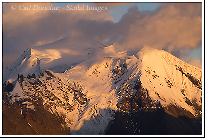
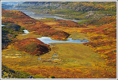
Here’s another image from a few years ago – on a trip to Wolverine, a ridge high above the Chitistone River in Wrangell-St. Elias National Park, Alaska. The Twaharpies Mountains lie south of the ridge, across the river, and came out late this evening with some gorgeous light. The peaks are pretty cool – classic alps. Just east of this peak lie the University Range, home to Mount Bona and Mount Churchill.
Wolverine is a local name for the (officially) unnamed ridge on the north side of the Chitistone River, and a great spot for a basecamp or a point to point hike – I usually hike from Skolai Pass west to Wolverine, but some folks like to do it in the other direction. It’s a classic alpine walk, through some of the most magnificent scenery I’ve ever stumbled my way through. There’s a crazy butte on the north side of the ridge, like something out of the desert southwest, but all around are jagged craggy peaks, like the Twaharpies.
Maybe I’ll continue on with a short series of images from years gone by, rather than continually posting new photos. This counts as 2. 🙂
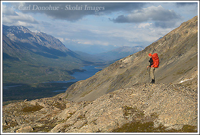
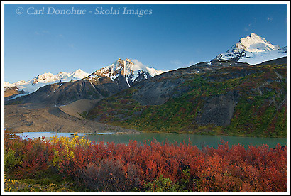
Here’s what happens when the guide lets someone else lead. Sergei, aka, Borat, was confident of his ability to lead us to our next campsite. he’d been in this area with me last year, and figured he knew the way. So I said ‘sure, you go on ahead’, we’ll follow you. We were aiming to stay on the southern side of this ridge, staying well below the crest, traversing around to our campsite. Sergei pushed higher and higher t every opportunity, and before ya know it, we came over the top, looking toward Tebay Lakes to the north of us. Jodee’s standing here, looking around asking herself “What The Heck?” and the rest of the group had collapsed on the ground.
🙂
Well, that’s not QUITE the truth, but Sergei did lead us up this ridge – and it was a pretty sweet spot to hang out for a while.
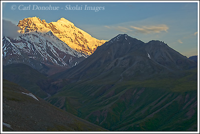
Here’s another image of Mount Drum from earlier in the summer – one fine, crusty and cold morning up on the windswept Sanford Plateau. We traversed the plateau from the north-west side, where we’d landed by bush plane along the Sanford River. Rather than cross the Sanford River, a foolish maneuver, we hiked over the glacial moraine, just above where the river comes out of the bottom of the glacier. The river was fairly rippin’ along, with all the rain this summer, so I was glad we didn’t have to wade it – I’m pretty sure the folks on the trip were glad about that too.
Most of that trip we had cloudy skies and light drizzle, although the rain really wasn’t that bad.
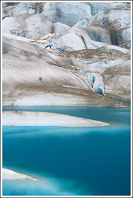
Here’s another image from the Tana Glacier – this one from our afternoon hiking around on the ice. We kinda found this little blue tarn by accident – I hadn’t seen it from the air, and didn’t see it at all until I nearly walked right into it. I hiked over this little crest and right beneath me is this incredible blue pond. I took a few images here, but it was drizzling rain most of the time, so I moved on up the glacier towards an ice cave I had seen from afar. In hindsight, I wish I’d spent more time at the tarn – the colors and patterns to be had were infinite.
Glaciers really are a pot pourri for a photographer – they offer such an array of compositions, from close intimate abstract shots of patterns and colors to wider, expansive landscapes. They’re cool to shoot (now that’s a good pun! 🙂 ) from the air, and they’re great to shoot from on foot. This was my first time on the Tana Glacier, and it’s funny how each glacier has his/her own personality – they’re tons of fun. But it can also be dangerous to explore them, so if you head out in glacier country, be careful.
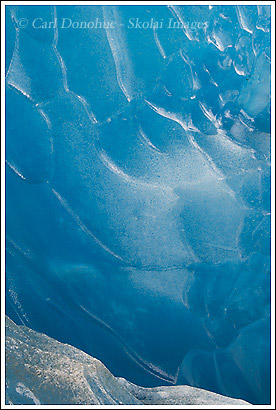
Ice Cave, Tana Glacier
Here’s another from the Tana Glacier, only this time from in a little ice cave I spotted. Well, I didn’t venture too far into it, it was more of a bridge than a cave, but I went inside enough to get dripped on. Pretty cool. The blue inside these glaciers is so vivid – it’s exciting to see it, weird as that sounds, that a mere color might excite someone.
I shot this image, as with most of these compositions, with and without a polarizer, to see the effect, and to get a couple of different takes. I tended to like the images with less polarization, where the glare shows a bit more. A polarizer filter, much like a pair of polarizing sunglasses, can almost completely get rid of the glare in a place like this. But I found the images didn’t grab me as directly. I liked the edges the glare created
Thompson Ridge
Here’s one of the few images I’ve made this summer with blue sky! This particular afternoon we got a little light, and I hiked and photographed as much as I could. Of course, by the time the light started to get really warm, low cloud rolled in from the southwest and all went flat again.
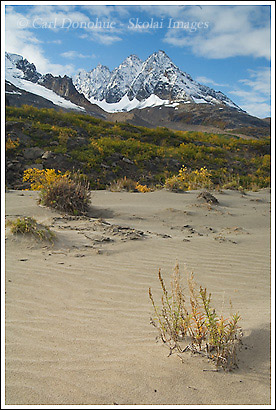
I like this scene, with the sand dunes undulating beneath the spires of Thompson Ridge. Ross Green Lake lies between the green willow-covered ridge in the middle ground and the jagged crags of Thompson Ridge beyond.
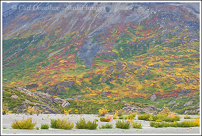
Here’s another image from the recent trip to Ross Green Lake. This one from down on the riverbed, looking across the sand dunes toward the ridge to the north-east and the rich fall colors there. The myriad different tones and colors on display were enticing – unfortunately the brush is not quite as welcoming to walk through as it is inviting to do so.
Fall is over way too quickly here in Alaska (like summer) and I’m keen to get back to the park and capture some more photos of the great fall colors this year.
At the headwaters of the Tana River, near Ross Green Lake, the glacial silt from the numerous glaciers and ice fields in the area is blown about the incessant wind, and there are some incredible sand dunes down the Tana.
We landed at the airstrip at Ross Green Lake, and were immediately taken by the cool landscape around us. Jagged snow-capped crags and spires sank into the clouds south of us (Thompson Ridge), a myriad of fall color sparkled on the hillsides, a deep cool lakes of every hue nestled into the depressions in the valley, the Tana glacier fell into pieces at its terminus to our west, and rippled sand dunes and waves of fine sand patterned themselves beneath our feet. ‘Cool’ is the only word that describes the place.
The weather was also cool – cold, at times, windy, cloudy, rainy, and snow fell on the peaks above us several of the nights we were camped in the area.
Some more light would’ve been sweet, but one does what one can in the outdoors. Both times the sun came out to greet us mid-afternoon it was gone before sunset – high, flat clouds rolled in, quickly, from the coast and brought stormy weather and flat, gray light – not so good for photography.
I’ll try to post a few images from this trip over the next week or so, and give you an idea of the landscape we hiked and explored.
Fall in Wrangell-St. Elias National Park
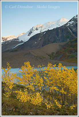
Aspens, Ross Green Lake
Here’s another image from the one evening we got any light. This was just after some clouds rolled in and began to block out the sun again. A few minutes after I took this image there was no light left on the peaks. The peaks are part of Thompson Ridge. Thompson Ridge is named after J.B. Thompson, a prospector who crossed the area on foot in 1906. There is a pass west of here, outside the park across the Copper River, called Thompson Pass, that’s pretty well known – it’s on the highway system.
This little patch of aspen in the foreground were really cool. We didn’t see any other trees in the area at all, except for one small white spruce across the valley, maybe a mile away. And here, on the edge of Ross Green Lake, is this stand of aspen. A few minutes earlier they’d been basking in gorgeous warm light, and then those nefarious clouds came a-rollin’ in! Bah!
Here’s another from my ‘sunny afternoon’. The sky started to clear around 10am, and by mid-afternoon, it was beautiful. I was hiking up the valley, east, trying to get some nice views, and maybe find a nice location to shoot sunset images from. I did find some spots, but it was in vain, of course, because yet another storm came rolling in from the west, and the light waned. Pesky clouds!
This image is looking west, towards the Tana River and Tana Glacier. You can see the edge of the sand dunes in the background, just behind that ridge, before you get to the winding, meandering river bed.
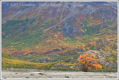
Dwarf Birch and Thompson Ridge
Here’s another photo from the nice evening we got at Ross Green Lake. As the last of the light faded, I headed up over this small ridge to this patch of dwarf birch that I had found earlier in the afternoon. The red brush is the Dwarf Birch (Betula borealis) – a spectacular bush in the fall – it’s pretty hard to hike through, though – not much fun at all. But how it redeems itself in the fall – what a beautiful plant. Now if only we can do something about that alder. ?
In case you didn’t see the earlier post, this is Ross Green Lake and Thompson Ridge in the background.
Willows and Sand Dunes
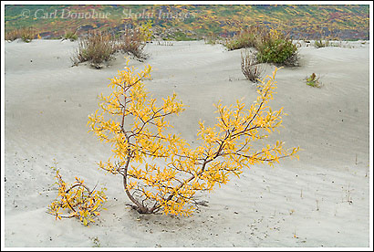
Here’s another from the Tana River sand dunes. We were basecamped in the area, day hiking up, down, and around the region. Every morning we’d walk right past this little willow bush to our kitchen, and then back again to our camp. Every night we’d do the same. I kept thinking “I gotta shoot that bush, it’s SO cool”. One afternoon I did – I wish I could’ve got a little higher, to get a little more separation between the top of the bush and the shrubs in the background, but this was all I could manage.
Here’s another willow I wanted to shoot from the first time I saw it. The color was really unique on this one – there were 2 other willow maybe 30 yards from it, both the typical yellow. This one had this cool orangey color to it that I really liked. Not only were they same species, but they are the same plant – their roots connect under the sand. Willow are pretty hardy, and the only plant here in the sand dunes that could get higher than about 1′ tall – and some of these willows were 20′ tall. That says a bit, IMO, if they can grow 20 times higher than any other plant in the same region.
If you don’t think they’re a hardy plant – I can tell you from experience that hiking through a thicket willows will change your mind on that one pretty quickly. 🙂
Here’s another aerial photo I took, right before we landed at Ross Green Lake. This is the terminus of the Tana Glacier. This glacier sits just northwest of Mount St. Elias.
It used to be possible to hike from Ross Green Lake, east of here (to the left) across the glacier, and around to Iceberg Lake. As you can see from this photo, the Tana Glacier has become an array of crevasses – not something one can easily, or safely, hike across.
The route hasn’t been hiked in a few years. I wish I had an opportunity this trip to explore it a little more, and possibly find a new route across. It looked to me, from the air, like it was possible slightly to the north of here, but I can’t say without hiking it first, or at least a good look from the ground – from the air, in a place as vast as this, perspective is everything, and things are often not as they appear to be; the scale is so hard to gauge.
I like the story this photo tells – of the place of ice and water on rock, and how this stuff works. Look at the rock in the foreground, and the debris surrounding it, torn, cracked, splintered and shattered by power of the ice and a little gravity. In the background, you can clearly see a medial moraine, running down between the seam of 2 glaciers that run together off the great Bagley Icefield to create the Tana Glacier.
I did get to hike, one afternoon, down from our camp to the Tana Glacier and walk around it a bit. it’s amazing being on the ice. I’ll post some photos from that hike later.
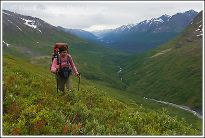
Here’s another image from the Harry’s Gulch section of the Bremner Mines to Tebay Lakes trip we did in August. This is Svetlana, or Sveta, as she hiked past me on the ridgeline. We decided a little further on that we were a tad high, and the sidehilling was a little slow, so we descended to easier walking down along the valley floor. A good decision, but I’m sure glad we spent time up high too – great views back east through the Chugach Mountains.
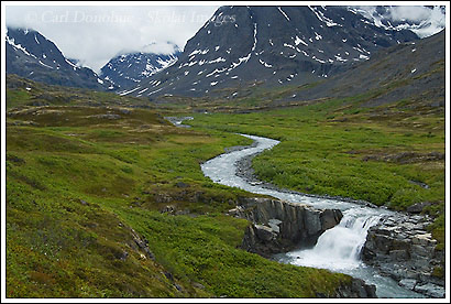
Here’s an image from the recent Bremner Mines to Tebay Lakes trip we did. This one is of a small waterfall we passed by as we paralleled the East Fork of the Little Bremner River, heading west down out of the pass at Harry’s Gulch. This was definitely one of the coolest sections of the hike.
The night before we camped on a grassy bench just below the pass, had a visit at dinner time from a grizzly bear, and then enjoyed a really delightful walk down the valley. The stream grew larger and larger as other tributaries ran into it – up at the head of the pass it was a fraction of the size it was here.
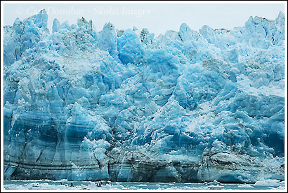
Well, this one is not from our last trip. This photo is of the Hubbard Glacier, from my trip in June down to SouthEast Alaska. The Hubbard is a well-known glacier, because it’s one of the most calvingest glaciers in the world. The Hubbard Glacier is over 70 miles long, reaching from it’s beginnings along the face of Mt. Logan, all the way to the Pacific Ocean, at Disenchantment Bay and the Russell Fjord. Lots of cruise ships pull in for a view, but because of the abundant icebergs in the bay, they keep their distance. Icebergs the size of a 10-story building frequently fall from the face of the Hubbard Glacier, not something one wants to be to close to.
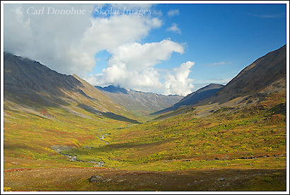
Here’s one of the few images I took on this recent trip – the weather wasn’t too great for photography, much as it hasn’t been all summer long. We started our hike with drizzly, cloudy socked in skies and and cold damp air. The weather improved a little over the 8 days, but never for long. The rain and cold threatened pretty much constantly. This particular morning the skies were partially clear, but by lunch time the clouds ad rolled in and the blue skies gone. I was hoping to get at least something from this area, because it’s such a great scene. The broad alpine valleys really appeal to me, the expansive Alaskan landscape feels so welcoming to walk through. This was taken right from our little kitchen area, and the fall colors were great. The evening before was dreary, though the damp air really made the colors pop a little more.
This was taken just east of Bremner Mines, in the Monahan Creek drainage, on our trek from Iceberg Lake to Bremner Mines.
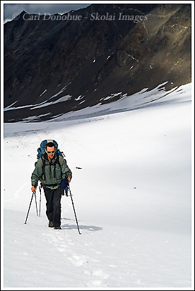
Here’s Sergei, also known as ‘Borat’. We ascended this pass on day 2 of our trip, in good weather, fortunately, and I scarpered ahead of some members of the group to grab a few photos. One of the few times I was close to the front of the group – it was a great group of hikers. Sergei acquired 2 nicknames this year – ‘Borat’, initially, because his Russian accent is almost a perfect rendition of the film character – his second nickname came a little later in the trip – Day 3, I believe. We’ll talk about that one on another post.
We had some great weather on this particular day, it cleared up nicely, and the hiking was superb – not too hot, but not raining. On this hike we went through 4 high alpine mountain passes, each of which was quite a slog. The first 2 were snow-covered, but the last 2 were snow free. This one had a nice glacier on both sides of the pass, which made good walking. The terminal moraine at the end of each glacier was a little more treacherous.