Hey Folks,
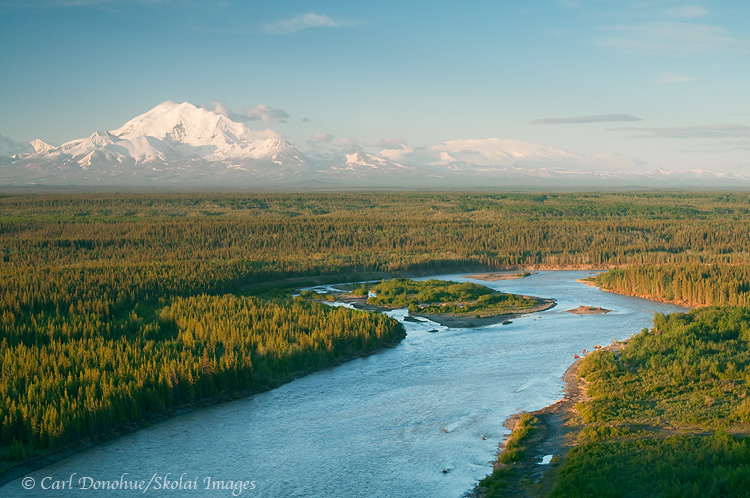
OK, enough with the waterfalls already! Here’s another image from my spring trip earlier this year, from Simpson Hill Overlook, off the Richardson Highway, near Glennallen, Alaska. This is a scene I’ll never tire of; looking down the Copper River, with the Wrangell Mountains in glorious sunshine. The mountains you can see in this image are Mt. Drum on the left and Mt. Wrangell the broader, dome-shaped mountain on the right in the background.
Just out of sight to the left of the frame is Mt. Sanford, and Mt. Blackburn to the right. How many vantage points do you know of in North America where you might choose to exclude from your photo two mountains both of which stand over 16 000′ high? That speaks volumes, in my opinion, about how amazing this viewpoint is. The 5th (Blackburn) and 6th tallest peaks (Sanford) in the US and they don’t make the photo? Craziness!
The Copper River is pretty grand too. Not to get bogged down by meaningless numbers and superlatives, but the Copper River is 300 miles long, and the 10th largest river, by volume, in the US. The Copper River is also the north and western boundaries of Wrangell-St. Elias National Park and Preserve, coolest park in all the world! It’s perhaps best known, however, for its nearly infamous Red Salmon run, usually over 2 million spawning salmon, loaded with fatty Omega-3 oils that make for some delicious supper.
I was really hoping for some sweet delicious alpenglow on this particular evening …. but ….. alas, such wasn’t to be my fortune. The light faded soon after I shot this – the boreal forest in the foreground grew dark, and the mountain light ebbed and dwindled; distant dim clouds low on the northwestern horizon thwarted my efforts at capturing some rich color on the snow-capped peaks, as seems to be the case all too often.
This scene is one of the very few ‘roadside‘ vantage points from which to photograph some of the big mountains in Wrangell-St. Elias National Park and Preserve. Willow Lake is another. The views on a clear day from these places rival anything I’ve seen anywhere else. The problem, I guess, for photographers is that the clear days are few and far between. Enjoy ’em when ya can! 🙂
Copper River and Mt. Drum, Wrangell St. Elias National Park, Alaska
Hey Folks,
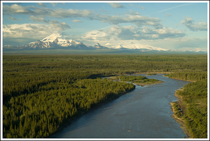
Here’s another image taken from Wrangell St. Elias National Park. This scene looks towards the park from the national Park boundary, the Copper River. Mt Drum and the Wrangell mountains oversee the immense Copper River Basin providing an incredible backdrop to this vastness. The Copper River is one of the largest rivers in Alaska, and also, like all large rivers, critical to the life and cultures of the ecosystems existing around it. The Copper River actually starts out on the east side of these mountains, on the Copper Glacier, which runs off Mt Wrangell.
Mt Wrangell is visible in this photo as the broad almost flat snow-covered peak rising directly above the island in the river. As this scene is taken from the north west corner of the park, it’s clear the river wraps around the mountain, starting on the east side, running north then west, then eventually running south, forming the western border of Wrangell-St. Elias National Park, all the way down through the Chugach Mountains, the Chugach National forest, forming the huge Copper River delta, and emptying into the Gulf of Alaska. The Copper River runs about 300 miles, or nearly 500 kilometers, from its beginnings in the Wrangell Mountains until it reaches the coast.
The Copper River has been important to people in the area for many years, for many reasons, but is primarily known today for the red salmon that run up it every summer to spawn. Copper River Reds, as they’re known, are widely regarded as some of the tastiest salmon in the world. They’re also known as Sockeye Salmon.And they sure are tasty!
The views towards the park from the Richardson Highway are as fine as they salmon that swim up the river are tasty. From various overlooks, it’s possible to see 4 mountains all standing over 12 000′ high, including 2 peaks over 16 000′ (Mt Sanford and Mt Wrangell). The Wrangell mountains are as impressive as any I’ve seen. Great photo opportunities can be found right off the highways (Richardson and also the Glen Highway), weather permitting, of course. These are all volcanic mountains, and have some dramatic features, Mt Drum, from the south side, is simply stunning.
Copper River in Winter
Simpson Hill Overlook

Here’s a photo I took last spring, just at start of the season Alaskans call “breakup”. This photo is taken from the roadside overlook just south of Glennallen, at Simpson Hill. Simpson Hill is rapidly disappearing, as the Copper River (in the foreground) erodes and cuts away at its base. Soon enough the spot may be known as “Simpson Mound”.
This is probably one of the very few (maybe 2) iconic view spots for the Wrangell Mountains and Wrangell-St. Elias National Park, the largest (and way coolest) National Park in the US. There are certainly many other grand views to be had, and amazing sites, but few that are so frequently photographed from.
The mountains, viewed from this spot, are simply awesome. From left to right, the mountains are Mt. Sanford, Mt. Drum, Mt Zanetti and Mt. Wrangell. Mt. Sanford is the highest of the 4, at 16 237′ tall. Next up is Mt. Wrangell, the broad round massif on the far right, at 14 136. Mt. Zanetti, the little “ski jump” looking cone that springs off Mt Wrangell, is 13 009′ tall, and Mt. Drum, front and center, is just over 12 thousand feet, at 12 010′ high. Those are some grand mountains. Most of the boreal forest in the foreground is white spruce, though there’s a cool band of aspen or poplar in the middle of the frame that can add a vibrant yellow to this scene in the fall. The mighty Copper River, defines the border of the National Park, running south to delta where it runs into Prince William Sound near Cordova. It’s fascinating to see how the river changes throughout the year, raging a turbulent, roaring silt-laden brown in early and mid-summer, clearing up through late fall as it’s volume decreases to a crystalline turquoise, to a frozen, ice-covered mystery in the winter.
It’s a magnificent viewpoint, and it’ll be interesting to see how it changes in the coming years, with the Copper River eating away so readily every summer. I was there last weekend, again, and noticed it’s even eroded further back than it was in the spring.
Note to visitors: If you DO perchance go to Simpson Hill to get this perspective on Wrangell St. Elias National Park and the Wrangell Mountains, I’d recommend parking in the paved parking lot, and walking the 100 yards or so back over to the edge .. driving over the little gravel road/trail to the edge can easily get you bogged and stuck, as the soil there is way muddy, and your tires can readily sink into it’s greasy depths. Not that this ever happened to me, of course .. 🙂 … but it can happen . so be careful up there. And hope you get some nice light. It’s a great vantage point in the evening.
Cheers
Carl
Carl,
That’s a worthy composition and a great view. I’ve had a tough time catching the skies clear enough down that way, but the options abound if you can score on it. I did however, following a long day of dipnetting salmon, get some good light on the mountains from the Willow Lake viewpoint. About 5:00am on a late August morning–it was very fine.
Someone might tell me about the ache in their back, and I could have a hard time feeling empathetic; but you mention low lying clouds on the western horizon, and boy do I ever feel your pain. It makes those rare sunsets all the more special though.
Hey Patrick,
Wow – you got light on the mountains at that time of day, in August? Given that Willow Lake is west of the mountains, I tend to think of that location as a sunset shot, unless you get some high cloud for sunrise. Maybe I need to give that a whirl? It’s a grand scene, for sure.
Hey Kent,
My thoughts exactly – that sweeping flat low cloud that spells the end of sunshine. 🙂
Cheers
Carl
Amazing scenery Carl. As I was flying home from Anchorage, I found myself both depressed for the lower 48 and pissed at the same time that we do not have vast stretches of landscape like this anymore in CA.
Hey Richard
Agreed … there are far too few large tracts of landscape left relatively alone in most parts of the world. this particular scene is a favorite of mine – it never fails to excite me when those big mountains roar up out of the clouds.
Cheers
Carl